Land is more than just dirt beneath our feet; it’s a vital asset that shapes our lives and communities. Whether you’re a homeowner, developer, or simply curious about property boundaries, understanding land surveying terms can be essential. One of the most fundamental methods used in land surveying is known as metes and bounds. This traditional approach has been guiding property delineations for centuries, yet many people may not fully grasp its significance or application.
In this guide, we’ll unravel the intricacies of metes and bounds surveying. From its historical roots to practical uses today, you’re about to become well-versed in this important topic that affects countless properties across the country. Ready to dive into the world of land measurement? Let’s get started!
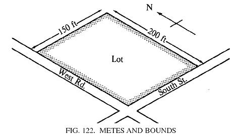
What is Metes and Bounds?
Metes and bounds is a method used in land surveying to define property boundaries. This technique relies on physical landmarks, distances, and angles rather than fixed lines or coordinates.
In metes and bounds surveys, “metes” refers to the measurements of distance. It often includes units like feet or meters. On the other hand, “bounds” describes the direction or limits of a parcel of land.
Surveyors use natural features like rivers, trees, and rocks as reference points. These markers help create an accurate description of the property’s perimeter.
This approach offers flexibility since it can adapt to irregularly shaped plots. Because each piece of land has unique characteristics, metes and bounds provides a personalized touch in defining ownership boundaries.
The History of Metes and Bounds Surveying
The origins of metes and bounds surveying trace back to ancient civilizations. The technique was commonly used by the Greeks and Romans, who relied on natural landmarks for land division.
As time progressed, this method found its way to England. Here, it became formalized in the 13th century through legal documentation. Landowners began using detailed descriptions based on physical features like rivers, trees, and hillsides.
When European settlers arrived in America, they brought metes and bounds with them. This system helped define property lines in a vast landscape that lacked established boundaries.
Over centuries, local customs influenced its application. While still prevalent today, adjustments have been made to accommodate modern needs while preserving historical practices.
Key Terminology in Metes and Bounds Surveying
When delving into metes and bounds surveying, familiarity with key terms is essential. “Metes” refers to the distance measurements between points. These are often expressed in feet or meters.
On the other hand, “bounds” describes the boundaries that enclose a parcel of land. This can include natural landmarks like rivers and trees or man-made features such as roads and fences.
Another important term is “monument,” which represents a physical marker placed on the ground to indicate property corners. Monuments can be stones, metal rods, or even wooden stakes.
Additionally, “course” signifies the direction of each segment of boundary lines within a survey. It’s typically articulated using compass directions like North or South along with angles.
Understanding these terms lays a solid foundation for anyone interested in land surveying concepts related to metes and bounds methods.
The Process of Conducting a Metes and Bounds Survey
Conducting a metes and bounds survey involves several precise steps to ensure accuracy. The surveyor begins by gathering existing property records, legal descriptions, and historical data related to the land. Having this information helps establish reference points.
Next, they use specialized equipment like GPS devices and total stations to measure distances and angles accurately. These measurements are crucial for defining boundaries clearly.
The surveyor then identifies key markers on the land—these could be trees, rocks, or man-made structures—that will serve as starting points in their calculations.
As they progress, detailed notes are taken regarding each marker’s location relative to others. This meticulous documentation is essential for creating a reliable boundary description that can be understood legally.
All findings are compiled into a formal report that includes maps outlining the surveyed area with its exact metes and bounds demarcated clearly.
Common Uses of Metes and Bounds Surveys
Metes and bounds surveys serve various practical purposes in real estate and land development. They are particularly useful for defining irregular plots of land that don’t fit standard shapes like rectangles or squares. This precision helps property owners understand their exact boundaries.
These surveys often come into play during property transactions, ensuring buyers know the limits of what they’re purchasing. Homeowners may also rely on them to resolve boundary disputes with neighbors.
In addition, metes and bounds descriptions can be crucial when applying for permits or zoning changes. Local governments frequently require detailed boundary information before development projects can move forward.
Land developers use these surveys to establish clear plans for construction, helping avoid costly mistakes later on. Their adaptability makes metes and bounds an essential tool in managing a diverse range of properties across urban and rural landscapes alike.
Advantages and Disadvantages of Metes and Bounds Surveys
Metes and bounds surveys offer distinct advantages for certain property owners. They provide precise measurements of land boundaries using physical markers, which can be beneficial in areas where traditional surveying methods fall short. This method is especially useful for irregularly shaped parcels, allowing for a more tailored approach to defining property lines.
However, there are drawbacks as well. The reliance on natural landmarks can lead to disputes over boundary interpretations if those landmarks change or become obscured over time. Additionally, metes and bounds descriptions may vary significantly between surveyors, causing confusion during real estate transactions.
Another concern involves the potential for inaccuracies due to human error in recording measurements or interpreting legal descriptions. These factors highlight the importance of working with skilled professionals who understand the nuances of this surveying technique and local regulations.
Conclusion: The Importance of Accurate Land Surveying for Property Ownership
Accurate land surveying is crucial for property ownership. It ensures that boundaries are clearly defined, protecting property rights and preventing disputes. Metes and bounds surveying provides a detailed description of land parcels, often using physical landmarks and measurements.
Understanding these surveys can help buyers make informed decisions during real estate transactions. Whether you’re purchasing a home or investing in land, knowing the specifics of metes and bounds can be invaluable.
Having precise survey data allows for better planning, development, and investment strategies. This level of detail promotes clarity in ownership claims. Accurate surveying leads to smoother transactions and greater peace of mind for all parties involved.